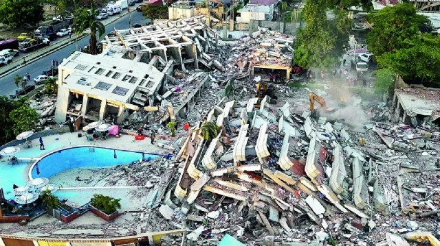
A preliminary satellite analysis has found that more than 58,000 buildings across Venezuela were damaged or destroyed by last week’s twin earthquakes, offering the clearest picture yet of the scale of destruction.
The magnitude 7.2 and 7.5 earthquakes killed roughly 1,700 people, with thousands more still missing, and rescue to take people out of buildings debris still underway.
Researchers Corey Scher and Jamon Van Den Hoek of Oregon State University estimated that approximately 58,870 buildings were likely damaged or destroyed across the affected region, based on satellite radar data collected on June 25, the day after the quakes struck.
The assessment drew on high-resolution radar imagery from the European Space Agency’s Sentinel-1 satellite. The researchers were careful to frame their findings as an early estimate rather than a confirmed count.
They described it as a rapid, preliminary assessment reflecting abrupt surface changes consistent with damage, cautioning that the figure had not been verified on the ground and should be treated only as an indicator of the disaster’s scope.
Read More: Aftershock Rattles Caracas as Venezuela Earthquake Death Toll Tops 1,700
The satellite-derived figure stands in sharp contrast to official numbers released by Venezuelan authorities. National Assembly President Jorge Rodriguez said on Monday that 855 buildings had been damaged, including 189 total collapses.
The gap likely reflects the difference between an automated detection method scanning a wide area and a government count based on confirmed, on-the-ground inspections, which typically take much longer to compile after a disaster of this magnitude.
NASA said its satellites are providing critical support to relief efforts, capturing imagery and data to help teams on the ground assess impacts and guide the response.
Satellite radar has increasingly become a first-response tool in major disasters, allowing scientists to flag likely damage zones within hours or days, long before ground crews can physically reach every affected community.
With the death toll still climbing and thousands unaccounted for, the wide gap between the satellite estimate and official damage figures underscores the scale of the assessment still ahead for Venezuelan authorities and international responders.
The full extent of destruction, and how many of the flagged buildings prove to be uninhabitable versus merely displaying minor damage, will likely become clearer as ground surveys expand in the coming weeks.